In this post we will take a look at how the fires that ravaged the East Adams Lake area in 2023 threatened to potentially destroy precious Salmon breading grounds in the Lower Adams River, and the work that is still being done to mitigate the damages and hopefully improve the Salmon Run for years to come.
The 2023 Wildfires
2023 saw one of the most destructive wildfire seasons in British Columbia’s recorded history, with more that 2.84 million hectares of forest and land burned, tens of thousands of people forced to evacuate and hundreds of homes and structures lost or damaged.

With the Adams Lake complex fire measuring over 10,004.9 hectares at its peak, and surrounding the Lower Adams River on all sides, the damage to the forests vegetation could cause serious erosion issues in the event of heavy rainfall. When a wildfire burns through an area, it burns up most if not all vegetation, leaving the soil compromised not able to absorb the moisture of a heavy rainfall. If you couple this scenario with steep terrain, the water that is not absorbed can run and carry debris with it. This water and debris all flow and settle in the river systems. This erosion would severely impact the Lower Adams River and would pose a serious risk to a large population of salmon that rely heavily on this section of river for their annual spawning grounds.

The Salmon Run
“A salmon run is an annual fish migration event where many salmonid species, which are typically hatched in fresh water and live most of their adult life downstream in the ocean, swim back against the stream to the upper reaches of rivers to spawn on the gravel beds of small creeks.” – wikipedia
The Lower Adams River is one of the largest annual spawning grounds in BC for several Salmon species. In the third week of August, the late-run sockeye salmon run alone was estimated to be nearly 4.5 million returning to the Lower Adams River spawning grounds. With such a large population of Salmon dependent on this river system something had to be done to protect the Salmon’s spawning grounds. To answer the call for action was the Skwlāx First Nations Band.

Skwlāx te Secwepemcu’lecw (formerly Little Shuswap Lake Band)
Bathymetric Survey
This section will take a look at how Rekon used their Bathymetry system to survey the Lower Adams River floor elevations to “fill in” the missing river sections of topography data from the LiDAR survey. But first, what is Bathymetry?

Wikipedia describes Bathymetry as “the study of underwater depth of ocean floors (seabed topography), lake floors, or river floors. In other words, bathymetry is the underwater equivalent to hypsometry or topography“. For visual representation, see the image below from an article in LiDAR Magazine “Overcoming Hurdles to Modeling River Bathymetry”. Check it out the article here!
(image supplied by https://lidarmag.com/2019/05/08/overcoming-hurdles-to-modeling-river-bathymetry/)

The first component to collecting bathymetry data is the vehicle. At Rekon we deploy an Unmanned Survey Vehicle, or USV made by Bathycat, designed to complete bathymetric surveys with a single beam echo sounder while remaining safely on the shore or river banks. This catamaran style USV is remotely piloted with two forward and reverse thrusters that can carry out manual maneuvering or automated missions.

The second component to collecting bathymetry data is the depth measuring device or sensor. Integrated into the Bathycat is a survey grade 200kHz single beam echo sounder, capable of collecting data points at a ping rate of 1Hz – 10Hz (1-10 soundings per second) from a minimum depth of 0.4m (1.3 ft) up to 100m (328ft) deep. It is also capable of being mounted on other watercraft such as kayaks, rafts or motorized boats which allows us to choose the right watercraft for the waterway so we can collect accurate data safely.

The third component of collecting Bathymetry data is the GNSS receiver or GPS survey receiver. This multi-band RTK GNSS receiver is capable of centimeter precision and communicates via Wifi with the Bathycat onboard computer to record position data along with the elevation data from the echo sounder.

Data Collection
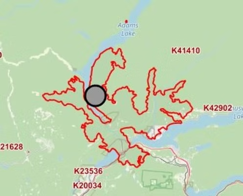
In the planning phase of the project, the Bathymetry missions were created to ensure adequate coverage of the river in approximately 5-10m cross sections, as seen below. However the urgency of project, the water levels, partly submerged obstacles and swift current of the Lower Adams River meant collecting the data while operating the USV fully manual was the safest choice.

Conducting the missions manually meant that the pilot had to be able to maneuver the USV visually across the rivers swift current. This meant the pilot had to traverse the entire 3.5km section of river from the Adams River Raft Pullout located near the Squilax – Anglemont Road Bridge to the mouth of Shuswap Lake. This section of river is where most of the debris collects into dangerous log jams, sweepers that cut across the river channels and sometimes underwater hang-ups like stumps and other debris.
Due to how fast the current was moving it was decided that an experienced riverman would traverse downriver roughly 100yds ahead and would act as a safety to catch the USV in the event that the pilot lost control or the current swept the USV away. A special thank you Skwlāx coordinator Cammeo for providing such an experienced riverman, Leigh was an incredible asset on this project.


This method was repeated in all side channels as well as the main river channel. Moving down the river roughly 100yds at a time, the pilot could operate the USV diagonally across the river collecting points roughly every 1 second. This meant that every crossing was recording a cross sectional profile across the river with roughly 10-30 points. All this data was collected and stored on the onboard computer which needed to be checked for quality before moving on down river to the next safe docking location. As you can imagine, this process took a long time. Luckily the weather was on our side and all our operators are well versed in navigating wild BC rivers. We stayed dry…most of us anyway.
LIDAR & Photogrammetry
Along with the Bathymetry Survey, LiDAR and Photogrammetry data was collected for the area surrounding the Lower Adams River for the Hydrological Study. The 170Ha LiDAR and Photogrammetry Mapping area was expanded from the original scope to include more old side channels in the Hydrological Survey.


There were 4 LiDAR mapping missions, roughly 50min each, covering approximately 44.5Ha each. Each mission comprised of a manually operated figure 8 maneuver to calibrate the LiDAR, then a low and slow target pass of 50m AGL at 3m/s and finally on to the LiDAR’s grid pattern mission at 120m at 6m/s with a 75% overlap. For more information on Drone LiDAR and Aerial LiDAR Scanning visit our LiDAR page.

The Photogrammetry missions were comprised of 3 missions. Two missions were approximately 66Ha and 75min long, with the third mission making up the remainder at 40Ha and 45min long. The Photogrammetry missions were flown at 120m AGL with an 80% by 80% overlap to achieve a 1.5cm GSD or ground sampling distance. For more information on Photogrammetry.
Data Processing
For processing of the Bathymetry data, “Hydromagic” software was used to combine the GNSS data from the receiver with the echo sounder data to produce points with latitude, longitude and elevation for every depth reading that was taken along the river. These points could then be integrated into the LiDAR and Photogrammetry point cloud data for a more comprehensive topography. From this combined point cloud, a DEM (digital elevation model) or “Bare Earth Model” could be produced that includes the river channel. With the additional river channel elevations a better Hydrological model can be made. From this accurate model, engineers have much better data to work with when assessing the issues and making their designs.

Although Rekon’s portion of the project is completed, the Hydrological study is still being worked on. The engineering team are working diligently to assess the damage from previous year, assess the risk of future erosion and also plan for increasing the rivers capacity for more spawning grounds in the future. This project will continue to be monitored and implemented in the coming years by the Skwalx First Nations Band and their project management team. Perhaps we will be back to conduct more surveys, but for now we are just excited to have been part such an amazing project with incredible people doing such necessary work.
